Lake Agassiz impacted Otter Tail County
News | Published on January 31, 2023 at 2:53pm EST | Author: henningmaster
0Massive lake was four times bigger than Lake Superior
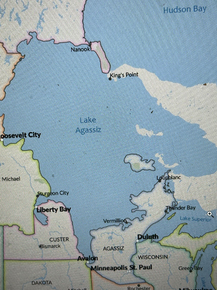
Lake Agassiz was more than four times the size of Lake Superior.
By Tom Hintgen
Otter Tail County Correspondent
Many people driving along Highway 210 just west of the Fergus Falls municipal airport visualize what was once the shoreline of the massive Lake Agassiz.
This huge lake, 12,000 years ago, was more than four times the size of Lake Superior. Eventually, with the retreat of the ice age, a channel to the north drained Lake Agassiz into Hudson Bay. This drainage left lakes Winnipeg, Manitoba and Lake of the Woods as remnants.
“This was drainage of the second Lake Agassiz,” says local historian Jim Welander, a Fergus Falls jeweler of 52 years. He has studied Lake Aggasiz in depth while relying on his Bachelor and Master’s credits in Geology at the University of North Dakota.
“The Lake Agassiz beaches are best observed driving toward Fergus Falls on Highway 210 from the west,” Welander said. “They are fairly subtle to discern.”
The best way to see the Lake Agassiz beach is from the air.
“Pilots follow the gravel pits in the sand ridge,” he said.
The Red River Basin has its origins in Glacial Lake Aggasiz. The river flows north through a wide ancient lake plain to Lake Winnipeg.
Welander points out two phases of Lake Agassiz.
“The first one drained out through Browns Valley, into glacial River Warren, carving out a huge flood channel,” Welander explained. “This is estimated to have lasted nine months. The Minnesota River now occupies this channel.”
Lake Agassiz was dry for close to 300 years, and then there was the return of the glaciers.
“That’s when Lake Agassiz number 2 formed, occupying the same lake basin,” Welander said. “The second lake drained into Lake Superior, Hudson Bay and the Arctic Ocean.”
Lake Agassiz covered the eastern third of North Dakota, Manitoba and Ontario.
Lake size varied with the advance of the mile-thick glacier of ice to the north.
Welander says Fergus Falls is an excellent area to observe glacial geology.
“The Ice Age lasted thousands of years, and what later became Otter Tail County had three major glaciations,” he said.
Major observable features are the flat Lake Agassiz lake plain west of Fergus Falls. A 300-400 foot thick glacial till covers the middle of the county, with multiple lakes, sloughs and ponds.
“Added to the aforementioned is the sandy outwash region of eastern Otter Tail County,” notes Welander.
Driving north of Erhard on Highway 59, a person can see the high ridge to the east, formed of sediment from the side of the glacier called a lateral moraine.
“The big hill five miles north of Fergus Falls, along Highway 27, is an end moraine,” Welander said. “That’s where the conveyor belt of ice and gravel was melting as fast as it advanced, dumping its contents.”
The two gravel pits south of the hill represent deposition from an earlier location of the Pelican River. Another end moraine is just north of Long Lake, north of Jewett Lake.
“As Lake Agassiz was a fresh water lake, it’s flora and fauna (plants and animals) would have represented that from feeder rivers, such as the Otter Tail River,” Welander says.
In a warm spring Agassiz’s southern tip would melt open first.
“Fish would spawn in warm water rivers, including the Otter Tail River,” adds Welander. “The fish would swim upstream to the first warm water lake, Opperman Lake in what later became Fergus Falls.”
Lake Agassiz also was well known to the late Al Seltz of Fergus Falls who authored the book, “History of the Otter Tail River.”
(There will be follow-up stories, periodically, about Lake Agassiz and its effects on what later became Otter Tail County.)